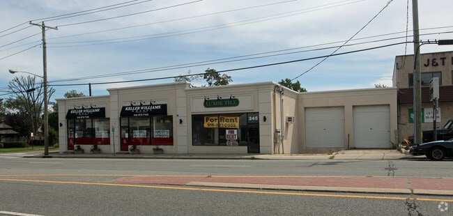
Property Record
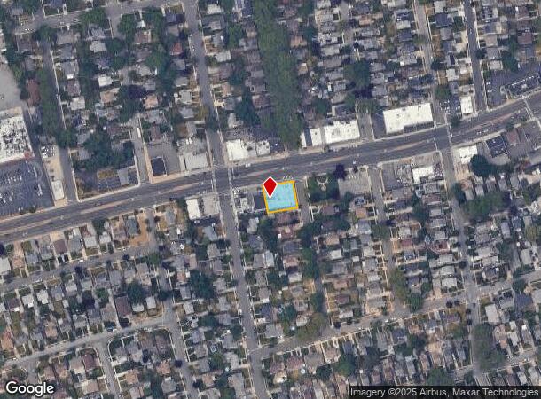
345 Hillside Ave, Williston Park, NY 11596

Current Lease Availabilities
NEARBY LISTINGS FOR SALE OR LEASE
Property Detail
345 Hillside Ave
2223-09-271-00-0106-0
106-110
Commercialnec
Nassau
X
New York
36059C0119G
106-1
2025
0.21 AC
2025
Central Nassau
303600
Long Island (New York)
7,400 SF
Nassau County-Suffolk County, NY
DEMOGRAPHICS near 345 Hillside Ave
1 Mile
3 Mile
5 Mile
2024 Total Population
29,463
156,469
485,526
2029 Population
28,918
153,840
472,491
Pop Growth 2024-2029
(1.85%)
(1.68%)
(2.68%)
Average Age
42
43
42
2024 Total Households
10,093
53,130
156,662
HH Growth 2024-2029
(1.95%)
(1.71%)
(2.84%)
Median Household Inc
$130,449
$142,979
$118,513
Avg Household Size
2.90
2.90
3.00
2024 Avg HH Vehicles
2.00
2.00
2.00
Median Home Value
$733,341
$784,894
$723,831
Median Year Built
1950
1953
1953
Nearby Places
- Restaurants
- Banks
- Shops
- Fitness
- Groceries
PUBLIC TRANSPORTATION
TRANSIT/SUBWAY
East Williston Station (Oyster Bay Branch - Long Island Rail Road)
DRIVE
WALK
Distance
East Williston Station (Oyster Bay Branch - Long Island Rail Road)
2 min
17 min
0.9 mi
COMMUTER RAIL
East Williston Station (Oyster Bay Branch - Long Island Rail Road)
DRIVE
WALK
Distance
East Williston Station (Oyster Bay Branch - Long Island Rail Road)
2 min
17 min
0.9 mi
Mineola Station (Oyster Bay Branch - Long Island Rail Road, Port Jefferson Branch - Long Island Rail Road, Ronkonkoma Branch - Long Island Rail Road)
DRIVE
WALK
Distance
Mineola Station (Oyster Bay Branch - Long Island Rail Road, Port Jefferson Branch - Long Island Rail Road, Ronkonkoma Branch - Long Island Rail Road)
4 min
1.5 mi
AIRPORT
John F Kennedy International
DRIVE
WALK
Distance
John F Kennedy International
24 min
13.9 mi
LaGuardia
DRIVE
WALK
Distance
LaGuardia
25 min
14.9 mi
Westchester County
DRIVE
WALK
Distance
Westchester County
54 min
36.1 mi
Freight Ports
NY - Red Hook Container Terminal
DRIVE
WALK
Distance
NY - Red Hook Container Terminal
36 min
23.0 mi
Nearby Properties
Address
Land Use
TOTAL SIZE
Lot Size
Zoning
Address
Land Use
TOTAL SIZE
Lot Size
Zoning
1,667,567 SF
30 AC
R3-2
Address
Land Use
TOTAL SIZE
Lot Size
Zoning
356,093 SF
3 AC
R3-2
Address
Land Use
TOTAL SIZE
Lot Size
Zoning
5,322,666 SF
86.10 AC
Address
Land Use
TOTAL SIZE
Lot Size
Zoning
17,000 SF
0.65 AC
R2A
Address
Land Use
TOTAL SIZE
Lot Size
Zoning
1,197,283 SF
64.50 AC
Address
Land Use
TOTAL SIZE
Lot Size
Zoning
10,230 SF
0.51 AC
R2A
Address
Land Use
TOTAL SIZE
Lot Size
Zoning
1.86 AC
R3-2
Address
Land Use
TOTAL SIZE
Lot Size
Zoning
556,575 SF
11.46 AC
Address
Land Use
TOTAL SIZE
Lot Size
Zoning
9,020 SF
0.23 AC
R2A
Address
Land Use
TOTAL SIZE
Lot Size
Zoning
14,460 SF
0.54 AC
R2A
Address
Land Use
TOTAL SIZE
Lot Size
Zoning
7,740 SF
0.46 AC
R3-2
Address
Land Use
TOTAL SIZE
Lot Size
Zoning
680,630 SF
72.68 AC
Address
Land Use
TOTAL SIZE
Lot Size
Zoning
11,554 SF
0.35 AC
R2A
Address
Land Use
TOTAL SIZE
Lot Size
Zoning
9,750 SF
0.64 AC
R2A
Address
Land Use
TOTAL SIZE
Lot Size
Zoning
13,695 SF
0.23 AC
R3-2
Address
Land Use
TOTAL SIZE
Lot Size
Zoning
352,730 SF
41.04 AC
Address
Land Use
TOTAL SIZE
Lot Size
Zoning
29,224 SF
1.33 AC
Address
Land Use
TOTAL SIZE
Lot Size
Zoning
152,926 SF
30 AC
Address
Land Use
TOTAL SIZE
Lot Size
Zoning
277,200 SF
21.03 AC
Address
Land Use
TOTAL SIZE
Lot Size
Zoning
5,600 SF
0.09 AC
R3-2
Address
Land Use
TOTAL SIZE
Lot Size
Zoning
111,756 SF
21.24 AC
Address
Land Use
TOTAL SIZE
Lot Size
Zoning
63,600 SF
2 AC
Address
Land Use
TOTAL SIZE
Lot Size
Zoning
182,129 SF
1.51 AC
Address
Land Use
TOTAL SIZE
Lot Size
Zoning
152,783 SF
51.20 AC
Address
Land Use
TOTAL SIZE
Lot Size
Zoning
7,500 SF
0.28 AC
R2A
Address
Land Use
TOTAL SIZE
Lot Size
Zoning
2,700 SF
0.30 AC
R2A
Address
Land Use
TOTAL SIZE
Lot Size
Zoning
158,725 SF
24.46 AC
Address
Land Use
TOTAL SIZE
Lot Size
Zoning
399,955 SF
13.63 AC
Address
Land Use
TOTAL SIZE
Lot Size
Zoning
6,250 SF
0.23 AC
R3-2
Address
Land Use
TOTAL SIZE
Lot Size
Zoning
3,970 SF
0.26 AC
R2A
The World's #1 Commercial Real Estate Marketplace
Connect with us
© 2025 CoStar Group
The information above has been obtained from sources believed reliable. While we do not doubt its accuracy we have not verified it and make no guarantee, warranty or representation about it. It is your responsibility to independently confirm its accuracy and completeness. Any projections, opinions, assumptions, or estimates used are for example only and do not represent the current or future performance of the property. The value of this transaction to you depends on tax and other factors which should be evaluated by your tax, financial, and legal advisors. You and your advisors should conduct a careful, independent investigation of the property to determine to your satisfaction the suitability of the property for your needs.